New Zealand coastline mapping, monitoring and updating – Resilience to Nature’s Challenges (RNC)
Dr Emma Ryan, Senior Lecturer, Prof Mark Dickson, School of Environment

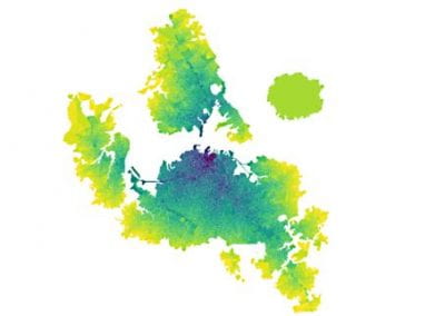
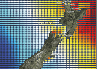
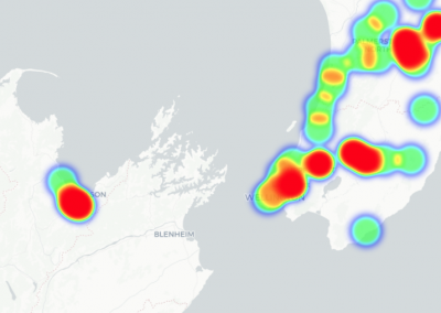
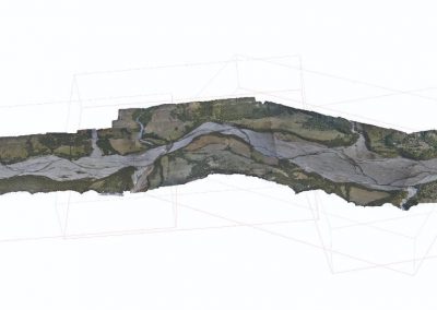
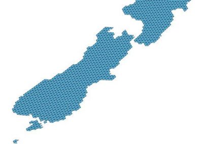
Coastal change since 1940s, mapped for part of the South Island’s West Coast, red = erosion and blue = accretion.
Overview
Comprehensive historical coastal change datasets are crucial resources for effective coastal management. Before the completion of the research detailed in this case study, available coastal change data for Aotearoa New Zealand was outdated and fragmented, hindering large-scale, long-term analysis of coastal change, and coastal planning nationwide.
Between 2019 and 2024 The University of Auckland led the Coastal Programme of the Resilience to Nature’s Challenges National Science Challenge. A core component of this work involved the compilation of New Zealand’s Coastal Change Dataset (NZCCD), which provides a detailed record of coastal change (coastal erosion and accretion) around New Zealand from the early 1940s to 2023.
The dataset was generated through a nationally consistent, rigorous process in which five coastal scientists manually interpreted and digitized the position of the coastline along New Zealand’s open and soft cliffed coasts, using historic aerial photographs and high-resolution satellite imagery. Rates of coastal erosion and accretion were then determined. Two resulting datasets are now publicly available: i) manually mapped coastlines, and ii) rates of coastal change derived at 10 m spacing around most of the nation’s coastline at https://coastalchange.nz/.
Researchers and practitioners can utilise New Zealand’s extensive coastal change dataset to explore the modes, styles and patterns of coastal change across New Zealand’s diverse coastal environments including sandy and gravel beaches, cliffed coasts, and active dunes. NZCCD also provides the necessary data to explore the influence of various drivers on coastal change in New Zealand and provides a baseline against which to evaluate future changes. This standardized and robust national dataset provides the necessary data to inform models projecting the future position of the coastline and for adaptation decision-making and hazard planning. Coastal erosion is becoming increasingly concerning as sea level rises, and sound projections of future coastal position require baseline understanding of historical coastal change, which the NZCCD now provides.
A wide range of stakeholders are already utilising these data, including coastal hazard managers and planners, who may use the data to develop and improve coastal hazard management strategies such as setback lines and rolling easements. In addition, the dataset is being used at national government level by the National Iwi Chairs Forum in their climate adaptation planning work. Consultants such as Pattle Delamore Partners, Tonkin and Taylor, and research organisations such as NIWA are also using the data. This dataset is also valuable to communities and individuals in New Zealand who can use NZCCD to gain detailed knowledge on coastal erosion risk at their local beaches.
The role of Centre for eResearch in the NZCCD work
The Centre for eResearch (CeR) assisted with several important stages of the work, which are detailed below.
1. Research Storage and Source Imagery
CeR provided the secure research storage, including regular backups, for the NZCCD. We could add and remove users to this research network as required, when new staff or students joined the team for example. Having a secure, backed-up, easy to use and large storage option was crucial, as we were dealing with 14.3 Terrabytes of imagery and data files.
New Zealand’s coastlines were digitised manually within ArcGIS from historical vertical aerial imagery (available for New Zealand since ~1940) and very high-resolution satellite imagery (available from early 2000s). Historic aerial imagery for New Zealand was accessed from New Zealand’s Crown Archive from Retrolens (Retrolens.co.nz), who provide unprocessed scans of aerial imagery, and from the Land Information New Zealand Data Service (data.linz.govt.nz), who provide published orthophotography. Satellite imagery was typically purchased from existing imagery archives. However, when commercial satellite imagery was not available for specific dates of interest, imagery was tasked by specifying criteria for location and date range for new image captures.
CeR wrote several scripts to assist with downloading and management of the imagery, including one script that generated videos of imagery through time, written by Nick Young. This work meant that our process was streamlined and much faster than it would have been without CeR’s assistance. The videos of imagery through time are particularly useful in hui with stakeholders, iwi and community to showcase the dataset.
2. Automated mapping of edge of coastal vegetation
Images were manually georeferenced and the position of coastal indicators (e.g. the edge of vegetation) were manually mapped by digitising. The manual mapping of the coastline was extremely time consuming and required coastal geomorphological knowledge to interpret the appropriate position of the edge of vegetation. CeR (Chris Seal, Nick Young and Nidhi Gowra) undertook a project to attempt automation of the mapping, using training data from the NZCCD and machine learning techniques. If successful, the project would result in dramatic improvements (time savings) in our research process. Interestingly, this project did not achieve the goal of automated mapping, due to the complex nature of digitising and decision process that experienced digitisers go through when discerning the true nature of a coastline indicator. However, the CeR provided several useful scripts along the way that were used in the project, including scripts to fix errors in file labelling, or scripts to find source imagery.
3. Coastal indicator and uncertainty work
Each section of coastline mapped has a degree of uncertainty in positioning, associated with errors in georeferencing and digitising and the photo pixel size. CeR wrote scripts that were used to automate the process of determining these uncertainty values and populating them in the shapefile data. Another valuable sub-project that CeR assisted with was comparing the coastal change rate and direction determined in NZCCD with rates and directions of coastal change derived from a national shoreline (waterline) database, which was made available in 2024. CeR helped extract and update the national shoreline database, which was used in analysis of coastal change using multiple indicators (the waterline shoreline and edge of vegetation). This research is now in review in a high-impact international journal.
4. Coastal erosion risk assessment
Once coastlines were mapped and data on coastal change rates generated, we undertook a national coastal erosion risk assessment to identify the most at-risk locations and assets to coastal erosion in New Zealand. Initially we developed the risk assessment approach via Lalita Garg’s Masters project for the Taranaki region, which CeR (Nick Young) assisted with (tidying and writing code, troubleshooting, providing research ideas, etc). This proved successful and CeR helped with generating a risk assessment for the entire country. This will be a hugely valuable resource for New Zealand and is the first national scale coastal erosion risk assessment undertaken.
The PhD research of Ben Collings was funded by the RNC coastal programme. During this period Ben developed automated methods for assessing coastal change using pixel-based analyses of multiple satellite images though time. Ben was subsequently employed by CeR and has since worked with us on a project to deliver an automated coastal change mapping system for Aotearoa New Zealand using methods he developed during his PhD research. The mapping system is now operational and under testing but has not yet been released publicly. This example demonstrates how fundamental research at PhD level can transition to public-good science, facilitated by CeR.
Summary
CeR were crucial in ensuring the timely delivery of this research project by providing assistance, scripts, advice and conducting projects throughout the four years. The outputs from this research are varied and will continue to be produced over the next few years and beyond. In total, we have published (or submitted/have in review) 9 journal articles, presented at over 7 conferences, produced two publicly available national datasets, and delivered presentations to end-users of the data nationwide. We are grateful to the CeR for their excellent services and have thoroughly enjoyed working with them. New Zealand’s Coastal Change Dataset was awarded the Terry Healy Coastal Project Award by the New Zealand Coastal Society, November 2024.

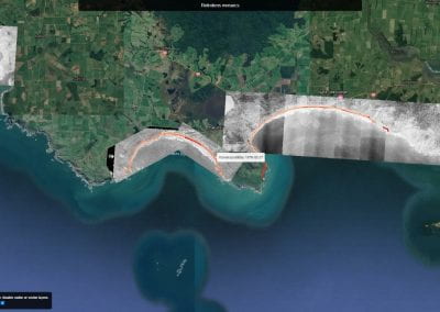
A coastline in the Tasman region, showing loss of a sand spit between 1938 and 2021.

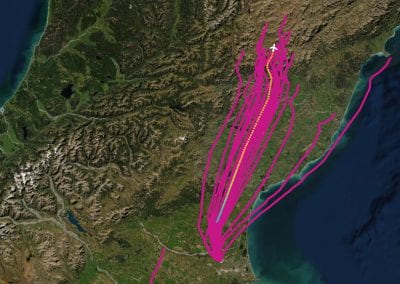
Different coloured lines show future projected cliff edge positions under different scenarios (colours represent different models and climate change scenarios) in 2100 at a coastline in South Taranaki.
Source: Garg, L. 2024. A coastal cliff erosion risk assessment of Taranaki under projected sea level rise scenarios. Masters thesis, The University of Auckland.

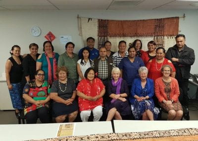
UoA researchers Dr Megan Tuck (left) and Prof Mark Dickson (right) with Sam Morgan (centre), Co-Chair of the New Zealand Coastal Society, during presentation of the Terry Healy Coastal Project award.
Source: New Zealand Coastal Society: https://www.linkedin.com/posts/new-zealand-coastal-society-068b92153_terry-healy-coastal-project-of-the-year-2024-activity-7267658457242054656-MdCg?utm_source=share&utm_medium=member_desktop
List of publications arising from this project:
- Ford, M. et al. In press. An assessment of the accuracy of shoreline indicators interpreted from aerial photos and very high-resolution satellite imagery. Journal of Coastal Research.
- Dickson, M. et al. In review. Coastal change analyses: should we be using multiple indicators? Submitted to Nature Communications, Dec 2024.
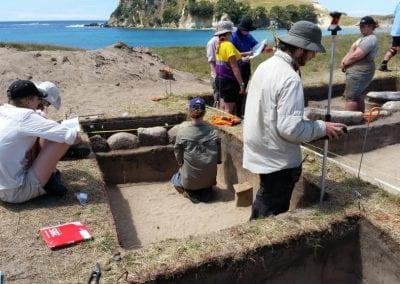
- Jones, B. D., Dickson, M. E., Ford, M., Hikuroa D., Ryan, E., Carrington, A., Chetham, J. (2024). Braiding archaeology, geomorphology, and indigenous knowledge to improve the understanding of local-scale coastal changes, Cambridge Prisms: Coastal Futures.
- Tuck, M., Dickson, M., Ryan, E., Ford, M. and Konlechner, T., (2024). A National Scale Coastal Change Dataset for Aotearoa New Zealand. Data in Brief: 111104.
- Jones, B.D., Collings, B., Dickson, M.E., Ford, M., Hikuroa, D., Bickler, S.H. and Ryan, E. (2024). Regional implementation of coastal erosion hazard zones for archaeological applications, Journal of Cultural Heritage, 67: 430-442.
- Jones, B.D., Dickson, M.E., Ford, M., Hikuroa, D. and Ryan, E.J. (2023). Aotearoa New Zealand’s coastal archaeological heritage: A geostatistical overview of threatened sites, The Journal of Island and Coastal Archaeology, 1-21.
- Ryan, E., Dickson, M., Ford, M., Tuck, M., Sengupta, M., & Lawrence, J. (2022). The use of historic and contemporary coastal-change data for adaptation decision making. In Coastal Adaptation: Adapting to Coastal Change and Hazard Risk in Aotearoa New Zealand. The New Zealand Coastal Society.
- Collings, B., Ford, M. & Dickson, M. (2022). A methodology for national scale coastal landcover mapping in New Zealand, Remote Sensing, 14(19), 4827.
- Collings, B., Ford, M.R., & Dickson, M.E. (2021). Identifying coastal land cover types using a hybrid approach of optical and SAR satellite data in the Auckland region. In Proceedings of the Australasian Coasts and Ports Conference 2021.
- Dickson, M., Ryan, E., & Ford, M. (2021). 80 years of shoreline change in Northland, New Zealand. In Proceedings of the Australasian Coasts and Ports Conference 2021.
List of key websites, news articles and social media posts
https://coastalchange.nz/
https://data.coastalchange.nz/
https://www.linkedin.com/posts/new-zealand-coastal-society-068b92153_terry-healy-coastal-project-of-the-year-2024-activity-7267658457242054656-MdCg?utm_source=share&utm_medium=member_desktop
https://www.linkedin.com/posts/emma-ryan-17b1b546_im-very-pleased-and-proud-to-present-a-national-activity-7232124679811911682-Ow02?utm_source=share&utm_medium=member_desktop
https://www.linkedin.com/posts/emma-ryan-17b1b546_two-important-documents-have-been-added-to-activity-7251752892611637248-I_7v?utm_source=share&utm_medium=member_desktop
https://www.planetaudio.org.nz/listen/senior-focus/the-voice-of-aucklands-senior-community/1152369
https://www.gisborneherald.co.nz/coastal-change-details-revealed-by-new-maps-city-beaches-are-growing-into-the-sea-year-on-year#2
https://www.scoop.co.nz/stories/SC2408/S00021/new-map-of-national-coastal-erosion-hotspots-shows-which-areasare-most-at-risk.htm
https://www.nzherald.co.nz/the-listener/new-zealand/archaeologists-race-against-rising-seas-and-eroding-coastlines-to-explore-threatened-nz-heritage-sites/GSVRV7Y63FC7DCFK77KHCVZDME/
https://fb.watch/rkmRtn1Mxl/
https://www.carbonnews.co.nz/story.asp?storyID=32277
https://www.nzherald.co.nz/hawkes-bay-today/news/eroding-new-zealand-new-maps-reveal-where-our-coasts-are-crumbling-fastest/OMWZHTQFQZHHPGDDWBBZPICCCE/
https://www.stuff.co.nz/environment/128550361/sounding-the-sealevel-rise-alarm-when-noone-is-listening
https://www.rnz.co.nz/news/national/508569/cyclone-gabrielle-parts-of-east-coast-lost-10-metres-of-shoreline-research-shows
https://www.nzherald.co.nz/waikato-news/news/cyclone-gabrielle-erosion-whangamata-beach-lost-15-metres-study-shows/DXX7XQCJBZHDRDFZAVFUBDDSSU/
https://www.nzherald.co.nz/nz/cyclone-gabrielle-what-weve-learned-about-nzs-monster-storm/SHL4L3WD7BHZJDRAWXMRTNDFJA/
https://www.nzherald.co.nz/nz/transformed-gabrielles-devastation-as-viewed-from-space/BZX563ZCPZGOPGVNXUGOF4A2MA/