Mapping livability: the “15-minute city” concept for car-dependent districts in Auckland, New Zealand
Jing Jiang1, Weijie Qiao1, I-Ting Chuang2, Tianyi Wang1, Yan Li1, Lee Beattie3
1 Doctoral Candidate in Architecture and Planning
2 Lecturer in Architecture and Planning
3 Senior Lecturer in Architecture and Planning
Introduction and methodology
The objective of this research is to undertake a comprehensive examination of the adaptability and practicability of the ‘15-minute city’ paradigm, specifically within the distinct urban landscapes of Auckland’s two selected neighbourhoods. The research adopts a methodological framework that includes the spatial demarcation of ‘livable areas’ and a One-Factor-At-a-Time (OFAT) experimental analysis. Employing Geographic Information System (GIS) methodologies with Python-aided data analytics, ‘livable areas’ are defined as spatial territories in which all 6 categories of essential services are accessible within a 15-minute walking radius. Subsequently, the OFAT analysis serves to quantify the relative significance of each essential service within these delineated zones. This methodological approach systematically omits one service variable at a time, thus facilitating an in-depth evaluation of its subsequent impact on the scope and integrity of the designated livable areas.
The OFAT analysis helps to pinpoint the potential areas that can yield maximum benefits if accessibility is improved, thereby informing strategies for the most efficient allocation of resources. These findings set the stage for exploring alternative mobility solutions that could further refine our understanding of livable urban spaces. The empirical findings reveal that the availability of essential services exerts a significant influence on urban livability, as illustrated by Figure 1.
Such observations yield actionable insights with significant implications for urban planning initiatives. The data thus collected provide a strategic foundation for the development of adaptive urbanism, which includes active mobility options such as electronic scooters and bicycles. This aligns effectively with the foundational principles of the 15-minute city concept. In Figure 2, we visualise the three most impactful services, overlaying them with areas potentially accessible through other active mobility options (Figure. 2).
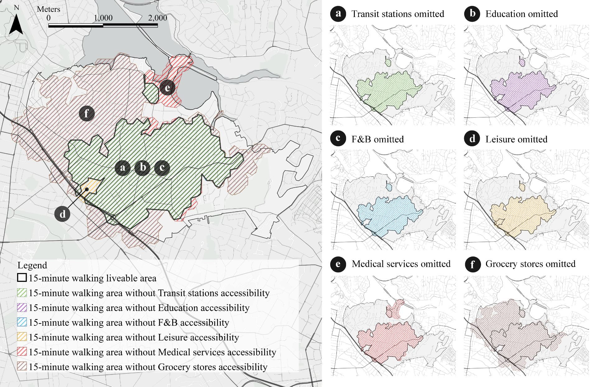
Figure 1. 15-minute areas with one type of service omitted in Remuera
Impacts
The research critically examines the potential of micro-mobility options, such as e-scooters and e-bikes, to significantly expand zones deemed ‘livable’ for the study sites. The findings reveal that these micro-mobility solutions markedly enhance the accessibility of substantial portions of these neighbourhoods, thereby adding an additional aspect to the conventional 15-minute walking radius and offering a more nuanced conceptualisation of which areas might be considered “livable”. Onehunga demonstrates superior livability attributes in terms of walkability and access to essential services compared to Remuera, which is characterised by a lower-density layout. Nonetheless, both locales exhibit the potential for significant enhancements in livability through the adoption of e-mobility solutions, with e-bike and e-scooter-accessible zones almost entirely enveloping Onehunga. The research further highlights the pivotal role that specific essential services, such as grocery stores and healthcare facilities, play in shaping these livable zones. The empirical data advocate for a more context-specific, nuanced approach to urban planning, one that incorporates advancements in micro-mobility. This not only suggests an expansion of the livable area but also signals a transformative reshaping of urban spaces to enhance their self-sufficiency and resilience.
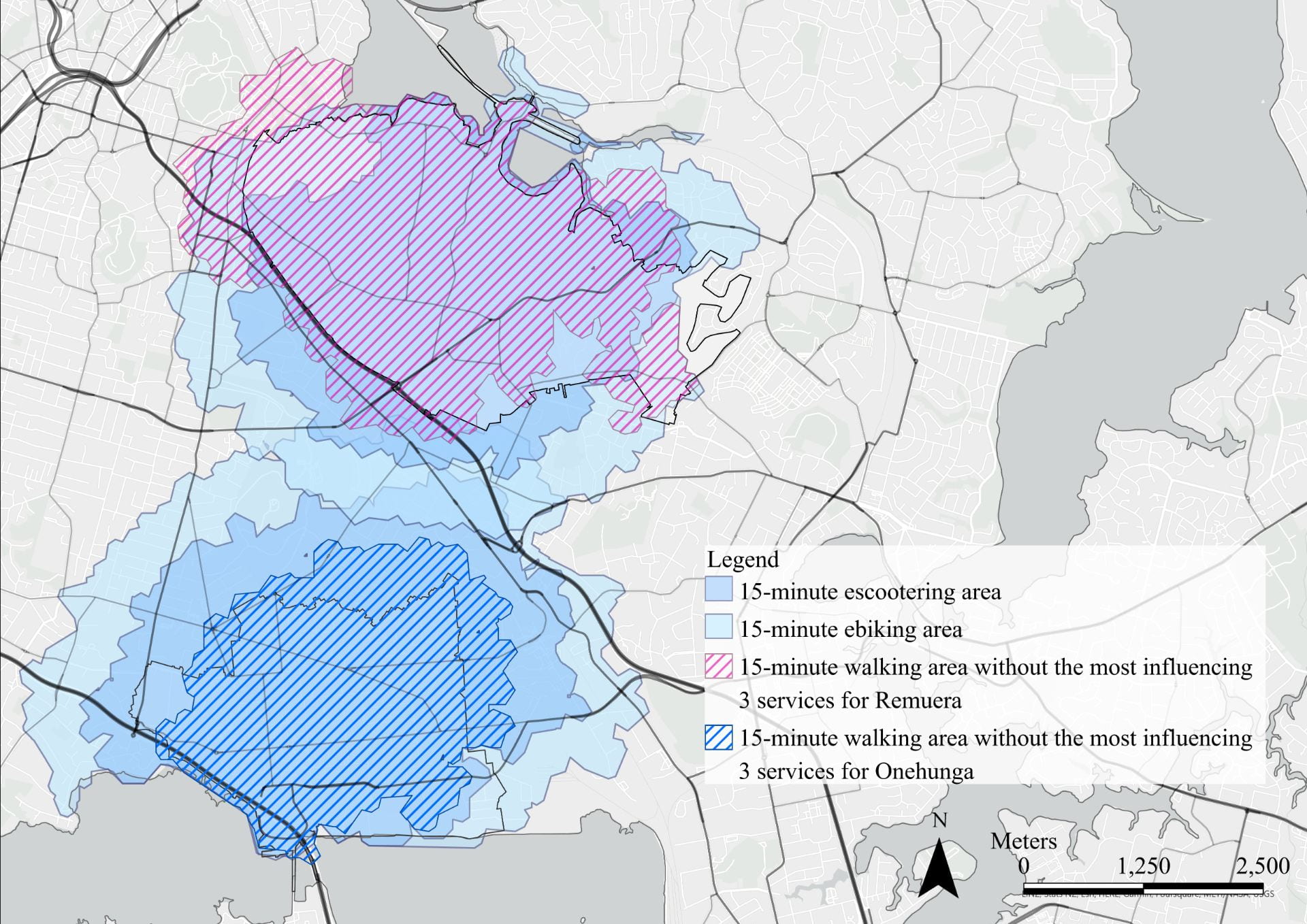
Figure 2. Comparative area of potential 15-minute liveable areas via micro-mobility in Remuera and Onehunga
We would like to acknowledge Nick Young from the Centre for eResearch to support the spatial and Geographic Information System (GIS) methodologies with Python-aided data analytics.
See more case study projects

Our Voices: using innovative techniques to collect, analyse and amplify the lived experiences of young people in Aotearoa
Painting the brain: multiplexed tissue labelling of human brain tissue to facilitate discoveries in neuroanatomy

Detecting anomalous matches in professional sports: a novel approach using advanced anomaly detection techniques

Benefits of linking routine medical records to the GUiNZ longitudinal birth cohort: Childhood injury predictors
Using a virtual machine-based machine learning algorithm to obtain comprehensive behavioural information in an in vivo Alzheimer’s disease model
Mapping livability: the “15-minute city” concept for car-dependent districts in Auckland, New Zealand
Travelling Heads – Measuring Reproducibility and Repeatability of Magnetic Resonance Imaging in Dementia
Novel Subject-Specific Method of Visualising Group Differences from Multiple DTI Metrics without Averaging
Re-assess urban spaces under COVID-19 impact: sensing Auckland social ‘hotspots’ with mobile location data
Aotearoa New Zealand’s changing coastline – Resilience to Nature’s Challenges (National Science Challenge)
Proteins under a computational microscope: designing in-silico strategies to understand and develop molecular functionalities in Life Sciences and Engineering
Coastal image classification and nalysis based on convolutional neural betworks and pattern recognition
Determinants of translation efficiency in the evolutionarily-divergent protist Trichomonas vaginalis
Measuring impact of entrepreneurship activities on students’ mindset, capabilities and entrepreneurial intentions

Using Zebra Finch data and deep learning classification to identify individual bird calls from audio recordings
Automated measurement of intracranial cerebrospinal fluid volume and outcome after endovascular thrombectomy for ischemic stroke
Using simple models to explore complex dynamics: A case study of macomona liliana (wedge-shell) and nutrient variations
Fully coupled thermo-hydro-mechanical modelling of permeability enhancement by the finite element method
Modelling dual reflux pressure swing adsorption (DR-PSA) units for gas separation in natural gas processing
Molecular phylogenetics uses genetic data to reconstruct the evolutionary history of individuals, populations or species
Wandering around the molecular landscape: embracing virtual reality as a research showcasing outreach and teaching tool


